21 September 2012

Medellín

Unlike Cartagena, this name is not attractive. I'd rather say “was not”. Indeed the times of Pablo Escobar and the Medellin cartel are far away. End of 1993, the murder of the drug baron brings peace and security in the city. Other cartels, such as the one of Cali, will be dismantled in the 1990s. Also, contrary to prejudices, the city as well as the rest of Colombia have gained a lot in terms of security. And the start of negotiations with the FARC (scheduled for October) even brings a wind of hope.

Between the Western and Central Cordilleras, Medellín (1,600 m) lies along a valley, the one of Rio Medellín. Known as the city of eternal spring, Medellín has a particularly pleasant climate: 25°C throughout the year with fresh air due to altitude. Surrounded by mountains, visible wherever you are in the city or in the suburbs, we forget that we are also surrounded by 3.5 million people. I was lucky enough to be hosted by Manuel, Alejo and Alex who live in the hills: great view of the city!

The city itself does not have much interest, post-aesthetic architecture worthy of the 1960s. But the surrounding areas, all in red brick, give a better picture of this megalopolis, especially when seen from the aerial tramway. I admit that it's funny to take these gondola lift in the midst of building or surrounded by greenery, while I am more used to take it to go skiing. Finally Arvi Park on the other side of the mountain is the perfect place for hiking.

In addition to sharing the lives of Manuel, Alejo and Alex, I had the opportunity to follow Manuel in his work. He is a journalist and director of the Emisora La Esquina, a community radio station. I followed him on the cover of Medellín Book Fair, at a street party organised for the defence of children's rights and I discovered behind the scenes of a radio broadcast. Almost excited to arrive in this city with such an history, I left behind me a city I enjoyed the environment and open-mindedness.

18 September 2012

Cartagena de Indias

A name that reminds us of the New World. A name that recalls those of the great navigators of the sixteenth century. But it is also a name closely linked to the slave trade and transit of gold spoiled from pre-Columbian civilisations. A name synonymous with rebellion: bastion of Spain in South America, it was the first Colombian city to declare its independence. More recently in the 1990's it was also the arrival port of the famous transatlantic yachting race, the Transat Jacques Vabre.

Cartagena is a walled city, declared World Heritage by UNESCO, which walls and fort are very well preserved. The old town has kept this highly colourful character of Spanish colonial towns. But today it is also a city of a million inhabitants, with its high modern buildings, tourist beaches and its suburbs that stretch for miles from the centre.

Cartagena was also a place for encounters. I met Anne, the German traveler I had already met several times in Mexico and Guatemala. I talked a lot with Diego and his wife Jamey, both from Cali, who offered me a good first summary of their country and the wonders to discover. And there was also Alex, Rocio, Jesus, Alfo and Cristian, the team of the hostel where I stayed a few days and with whom I had a great time.

Cartagena is the gateway to Colombia. Upon my arrival, I've felt at home. I could install without problems. Intense feeling I had not felt since Fairbanks Alaska. A sense of well-being, as if the safety “stress” prevailing in Central America dissipated. A bit like when you fall in love, it is sometimes difficult to describe that little extra that makes all the difference with others. But I feel that I will love this country, as I loved Cartagena.


10 September 2012

Best of Northern and Central America

I landed in Colombia. Landed indeed, as I had to resign myself to fly. Going from Panama to Colombia is not the easiest to manage: no road since the border is basically a 80 kilometre jungle strip, and only expensive small boats make the connection between the two countries.

So, here I am, in South America! I begin the second half of the trip. Indeed I left home 7 and a half months ago and it remains almost as much. Geographically speaking, it is also the half of the trip; I am equidistant from Fairbanks, Alaska and Ushuaia, Tierra del Fuego.

To remember the best moments, a little best-of this first part. Here are some awards in the following categories:
  • cuisine: El Salvador with its pupusas and yuca fried dumplings
  • breakfast: oat-meal with peanut butter, at Casey and Brad's in Anchorage
  • winter landscape: Fairbanks and the surrounding area
  • spring landscape: the wild Pacific coast of Oregon and Northern California
  • summer landscape: the desert State of Arizona, including Grand Canyon
  • climate: dry and cold Alaska or hot and dry Arizona. Further south, I like least: much more humid. In the tropics, it is the rainy season from June to November.
  • plant: a plant that retracts its leaves at outside contact. Viewed in Tikal, Guatemala.
  • tree: the huge redwoods of California
  • animal: the squirrel from North America
  • ecofriendly house: Mark and Megg's in Bolinas, CA
  • beach: in Tulum, Quintana Roo in Mexico (my only step on the Atlantic side) and in Zipolite, Oaxaca, Mexico
  • historical site: the ancient city of Monte Alban (State of Oaxaca, Mexico)

Now the highlights:
  • best shiver: arrival at the edge of Copper Canyon, State of Chihuahua (Mexico)
  • best shivers: in the Chena River hot springs, Alaska (40°C/105°F) with an outside temperature of -48°C/-55°F
  • best meetings: those with Andrew and Anna (Fairbanks, USA), Mike and Eve (Fort Bragg, USA), Roger (Great Falls, USA), and so many others...
  • best militant moment: afternoon with Chris, the movement Occupy Fairbanks
  • best hiking time: three day hike in the Grand Canyon and crossing on foot the Golden Gate Bridge
  • best community time: in Pinpin in the mountains of western Guatemala, with Elsa and Nico
  • best childhood-dream time: the Panama Canal and crossing the Bridge of the Americas
  • best hitchhiking: when a Canadian wanted to drop me off on a site emergency stop on the freeway, at -10°C (see also Hitch-hiking, another way to travel)

The best-of in photos is divided in three albums: 1. Alaska and Canada 2. United States 3. Mexico and Central America.
And you now know where to find the portraits!...


7 September 2012

Race Info

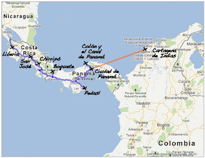
Day 229. Kilometer 26,080 (Mile 16,205). Latitude 10°24' North.

Last post about Central America.

I crossed Costa Rica quite fast. One step in Liberia, another in San Jose (capital city) and a few days in the mountains of Chirripó National Park (see post and photos: El Chirripó, on top of Costa Rica).

Then another fast crossing of Panama: a step in Boquete, near Volcán Barú, then in Pedasí on the south coast, and finally in Panama City and around the Canal (see post, photos and video: Panama, a country, a city, a canal).

From Panama City, I flew to Cartagena in Colombie. And since I just started the second half of my trip, I will soon post a best of concerning the first half in North and Central America.

Distance Liberia-Panama : 1,665 km (1,035 mi)

6 September 2012

Panama, a country, a city, a canal

It was all about surprise and delight. Surprise because I had planned a few days only in this country. But it eventually pleasantly surprised me. I didn't expect to find much very interesting; I left the country with the regret of not having stayed longer. Landscapes, cuisine (I become obsessive!), people, everything delighted me. A little less the climate. It feels like a greenhouse so the heat and humidity are oppressive.

Let's talk a little about the Pan American highway. Given the shape of the country, it is difficult not to drive it in Panama. But to be honest apart from a few dozens of kilometers at the border between Chiapas and Guatemala, I drove it on bus from Mexico City to Panama City. You will see some pictures of the road that connects almost continuously Northern Alaska to Tierra del Fuego in Argentina. Although in some places it is a real highway, sometimes it looks like a simple road crisscrossing the jungle. Whatever its form, there are still large semi-trailers traveling at breakneck speed.

After spending a day in the mountains of the west and two days on the south coast, with Kati (a Hungarian from Romania who lives in Ireland and with whom I traveled in Panama), we took the path the city of Panama. At the southern entrance to the canal of the same name, the city extends horizontally but also vertically. This cityscape is rare enough since San Francisco to be noticed. Far away in the bay, we see freighters waiting patiently for their entry into the canal.

The canal precisely! Well, I admit that I was as excited as a kid in the sandbox playing with a new toy (affectionate thoughts for my nephew!). I was initially excited by the moment. Crossing the canal on the Bridge of the Americas meant going from North to South America. I begin the second part of my trip. A symbolic moment that I did not think too hard at first.

Then, nothing better than to take the train along the canal to better understand how it works. Basically, two sets of locks, one to the south near Panama City, one in the north near Colon, a channel and an artificial lake between the two. And on the sides, from time to time a dam to prevent water from escaping otherwise than by locks, and another one just to refill the lake, which releases tons of water each time a boat is passing by locks.

Finally I arrived at the locks of the north, those of Gatun. There you would have probably seen me dumbfounded by those huge container ships towed by small locomotives along no less enormous communicating basins between locks. Everything is calibrated to the millimeter. Ballet of locomotives and slow parade of boats: it's fascinating! Crossing a set of locks takes a good hour for a ship, crossing the channel as a whole, about ten (excluding congestion at peak hours!). And further, finally, we see the work of pharaonic construction of new locks, larger than existing ones. Within two years, they allow the passage of even larger vessels. For the moment, the site is a huge trench in the clay soil.


For the curious ones, an internet search (starting with the detailed article from Wikipedia) can quench your thirst for knowledge. From my side, this time back to school, I saw myself back in time, at secondary school, studying the Panama Canal, trade across the world, the US-linked history of Panama through this channel etc.. And to see this wonder of engineering and to see what I only saw in pictures in my history and geography books brought me several years back. Fun sensation. And for the sailors I know, I guess crossing the canal by boat must be something!

And now here are the pictures and below, a video.