The Inca people is really amazing. At the mere mention of their name, are popping up images of the Andes, Machu Picchu, mummies and rich gold ornaments, etc.. But there are also many mysteries behind it. The word Inca denoting the Emperor above all, we speak of the people of the Inca. But it is also used as an adjective to describe the people and the empire, for example.
 The Inca Empire extended from just south of today's Colombia to northern Chile, including Ecuador, Bolivia and Peru. Cusco, the "navel [of the Inca world]" in Quechua, was its capital, founded in the eleventh century. Born on the shore of Lake Titicaca, the empire was gradually formed by assimilation of different civilisations surrounding, more or less by force.
 To meet their needs, they cultivated terraces perched on steep cliffs. They used the slopes of the mountain as huge recovery of rainwater and ingeniously irrigated their crops. It seems that the Incas knew socialism before it even was theorised: a system of redistribution of production was organised. Valleys which missed herds were provided with meat and wool and conversely highlands whose crops were insufficient were provided with agricultural products. To do this, they developed an extensive road network that the first Europeans who arrived on the continent even compared with what had undertaken the Romans in their time.
 Also surprising, studies have shown that the architecture responded perfectly to the anti-seismic standards (we are still on the Pacific Ring of Fire!). A mix of solid construction and fine settings: small stones able to move in foundations, on top of which megaliths of several tons fit perfectly without cement. It's almost comical to see the disproportion with the straw that covered the whole house and served as roof. It is for this reason that in the ruins, only the walls remain today.
 Arrived in Cuzco on 15 November with Henning (one of two Germans with whom I travel since my return from the Galapagos), I met again with Antoine, a French guy met on a summit in Costa Rica. He goes up South American from Argentina to Colombia (with an interesting blog to follow). We agreed on a four-day trek to Machu Picchu little brother: Choquequirao. The pretentiously underestimated hike tired us a lot. The accumulation of fatigue from the last busy weeks (lots of buses and hikes), the heat and the altitude made us doubt for a moment. But we had good laugh and hiked in a stunning scenery.
 A little history quickly. It will be short because the village of Machu Picchu has been inhabited a tiny hundred years. Its construction reportedly began in the 1440s. We still do not know now if it was a secondary residence of the Inca, a kind of Versailles of the Inca empire, outside the central government of Cuzco, where the Emperor could withdraw a portion of its court.
 Despite that, the empire fell to the Spaniards in the course of the sixteenth century. They then plundered everything that could be. The Kingdom of Spain has never been as rich as this time. Conquistadors took advantage also to evangelise the region. One can easily imagine that the Incas and their descendants have had difficulties to embrace this religion that advocates love and forgiveness on one side but tolerates on the other that his followers kill, loot massively, sack cities and villages, or extort vast natural resources.

The Incas lived mainly in the mountainous region of the Andes, perched at an average altitude of 3,000 m (10,000 ft). But these geographical constraints and conditions were far from discouraging them. Instead, it is their ability to adapt to this environment which has been their strength.
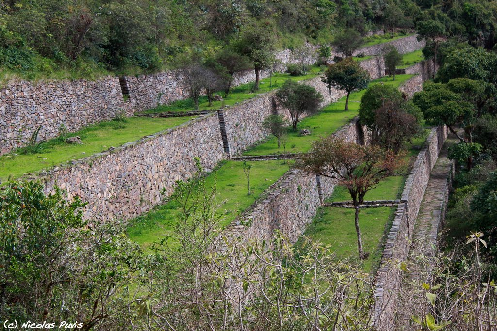 To meet their needs, they cultivated terraces perched on steep cliffs. They used the slopes of the mountain as huge recovery of rainwater and ingeniously irrigated their crops. It seems that the Incas knew socialism before it even was theorised: a system of redistribution of production was organised. Valleys which missed herds were provided with meat and wool and conversely highlands whose crops were insufficient were provided with agricultural products. To do this, they developed an extensive road network that the first Europeans who arrived on the continent even compared with what had undertaken the Romans in their time.
 Also surprising, studies have shown that the architecture responded perfectly to the anti-seismic standards (we are still on the Pacific Ring of Fire!). A mix of solid construction and fine settings: small stones able to move in foundations, on top of which megaliths of several tons fit perfectly without cement. It's almost comical to see the disproportion with the straw that covered the whole house and served as roof. It is for this reason that in the ruins, only the walls remain today.
The Incas had an acute knowledge of astronomy. They used solar calendars for dates, based on the same principle as the solar quadrants that give time. Thus, they knew precisely the seasons and the days of solstice and equinox. 21 or 22 June, they celebrated the winter solstice during the Festival of the Sun. In the southern hemisphere, this is the time of year when the sun is the farthest from the Earth. Therefore they worshiped him to make it coming back closer quickly.

On our return to Cuzco, Henning and I had always in mind to visit Machu Picchu. With the advice of fellow travelers, we were able to enjoy the site in the early morning, before the arrival of hordes of tourists. I was a little embarrassed to taking pictures, first in the fog, then under a blazing sun. But the site is magical. Perched on a hill, it is very well preserved and faithfully reproduces the atmosphere that could reign there 500 years ago.
 A little history quickly. It will be short because the village of Machu Picchu has been inhabited a tiny hundred years. Its construction reportedly began in the 1440s. We still do not know now if it was a secondary residence of the Inca, a kind of Versailles of the Inca empire, outside the central government of Cuzco, where the Emperor could withdraw a portion of its court.
The fact is that the Incas deserted the site by 1538. Following the capture of Cuzco by the Spanish, the site was abandoned, lest he too falls into the hands of the Spaniards. The Inca and some of his people took refuge farther to Choquequirao in particular. 100 years of existence, but the Spaniards have never discovered a priori the two sites (Machu Picchu and Choquequirao), the Inca destroying paths behind them. It was only in the 1910s they were rediscovered and remains gradually excavated from lush vegetation.
 Despite that, the empire fell to the Spaniards in the course of the sixteenth century. They then plundered everything that could be. The Kingdom of Spain has never been as rich as this time. Conquistadors took advantage also to evangelise the region. One can easily imagine that the Incas and their descendants have had difficulties to embrace this religion that advocates love and forgiveness on one side but tolerates on the other that his followers kill, loot massively, sack cities and villages, or extort vast natural resources.
Aztec or Mayan civilisations of today Mexico disappeared with the arrival of Spaniards. Despite many resistance movements active until independence, the Incas managed to accommodate themselves to the invader. Particularly from a religious point of view, they have cleverly managed to match Christian celebrations and rites with their own festivals. For example, they continued to celebrate the sun, but at the time of the feast of St. John (June 24), without anybody noticing! A mixture of "pagan" and Christian beliefs still present today.
So an exciting week in the heart of the Inca Empire, a week to learn a little more about this fascinating people living in an particularly hostile but beautiful Andean environment. And now there are still ruins, haloed by mystery, in which one walks to try to imagine the magnificence of this incredible civilisation.


